Biking It: Orrville to Seguin Falls
This is a follow on to the Tally Ho - Swords Road to Orrville post and covers the larger part of my ride on a warm sunny day. All of my rides involves riding the trail in both directions to get back to my car.
The Orrville to Seguin Falls is about 12 km (7 mi) one way. It's a managed trail area that is for the most part flat and alternately runs alongside lakes and through bush area. Along the first part of the trail leaving Orrville there are a few cottage and camp roads off to the side of the trail, but for the most part you feel as though you are away from civilization.
There are a few ups and downs on the trail, and there is one section where it seems Seguin Township decided to take over the trail for a local road and relegated the trail to running along the side.
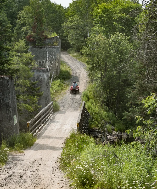
The ups and downs relate to bridges that have come to replace the original trail trestles. As you can imagine trains do not like going up or down over short runs, let's say anything less than a couple of kilometres (a mile). Gradual grades are okay but not steep dips, or rises. To that end the Seguin Trail, which is built on a former rail bed, is a cyclists dream. But that was then and this is now. In some cases the rail trestles were too expensive to maintain and were simply torn down and replaced by bridges that were are suitable for rail traffic but more than acceptable for motorized and non-motorized traffic. This is best seen at the bridge now crossing at Seguin Falls (below).
The old trestle structure alongside the bridge at Seguin Falls.
The image below provides a better sense of the size of these trestle support structures. This support at Seguin Falls has a tree growing on top of it. You get a sense of how in the past, with the trestles in place, the rail line effectively was flat as it crossed these streams and rivers.

Trestle support - Seguin Falls.
In some cases the original trestle structure is completely gone as it is here where the Seguin Trail crosses Fume Creek, and require a rough down and up for cyclists.

The Bridge at Fume Creek, another trestle converted to a bridge.
In other places you are crossing a land bridge that you don't realize is a bridge. A good example is when you pass over Diamond Lake. You see people fishing on one side, and water on the other side, but don't really appreciate that the two parts were/are a single body of water.

Fishing on Diamond Lake.
There is one other section of the trail worth mentioning. It is the section that runs along Chain of Lakes Road closer to the Seguin Falls end of this section. In this case the original rail bed was used for the road and the trail was forced to the side, This section has many ups and downs, and when wet some atrocious puddles that can swallow an ATV. I chose to ride along the paved road for this section and make up a little bit of time. The trail looked rough and would probably be rated a 4 or 4.5 according to the scale described in the next section.
All-in-all the run from Orrville to Seguin Falls is very pleasant for cyclists with some water to deal with, some bridges that may require you to get off the bike and walk, but mostly a flat and reasonably groomed trail. There are lots of beautiful views along this stretch. In terms of difficulty it probably rates a 2.5 on a scale of 1 to 5, with 1 being flat and paved and 5 being rough with plenty of hills. Plan on taking about an hour and a quarter each way for this stretch if you intend to stop and take pictures, or just enjoy the views.

Panorama from the Fume Creek Bridge.